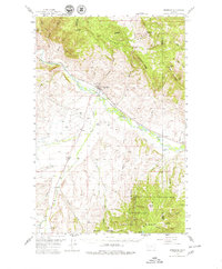
1958 Map of Drummond
USGS Topo · Published 1979About this map
Drummond sits at a critical rail junction in western Montana, where the Northern Pacific and Chicago Milwaukee St Paul and Pacific railroads converge along the banks of the Clark Fork. This 1950s survey documents the valley's established ranching and transportation network, showing small settlements like Hall, New Chicago, and Jens connected by a web of creek-side roads and irrigation ditches. To the south, the terrain rises sharply into the Deerlodge National Forest, where the Douglas Creek Ranger Station and Jackson Park mark the transition from the valley floor to the high country of Dunkleberg Ridge. Local history is preserved in the location of the Valley Cem and numerous named family landmarks like Gaskill Creek and Pattler Gulch. The map also details early aviation and utility infrastructure, including the Drummond Airport and several major Pipelines traversing the northern peaks of the Garnet Range.
Find a feature on this map
51 named features on this map. Tap any name to fly to it.
Don’t see what you’re looking for? This feature index may not catch every label — zoom into the map to look around manually.
Map Details
Editions of this 1958 Drummond Map
3 editions found
Other maps of this area

1889 · Helena
USGS Topo · 1:250,000

1893 · Helena
USGS Topo · 1:250,000

1899 · Helena
USGS Topo · 1:250,000

1903 · Helena
USGS Topo · 1:250,000

1908 · Philipsburg
USGS Topo · 1:125,000

1919 · Drummond
USGS Topo · 1:125,000

1921 · Drummond
USGS Topo · 1:125,000

1947 · Butte
USGS Topo · 1:250,000

1958 · Butte
USGS Topo · 1:250,000

1958 · Drummond
USGS Topo · 1:62,500