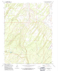
1994 Map of Dry Creek Basin
USGS Topo · Published 1994About this map
Olathe Reservoir No 1 and Olathe Reservoir No 2 anchor this high-altitude drainage basin where water management is central to the landscape. Located in the Montrose area, the terrain is defined by the convergence of the West Fork Dry Creek and East Fork Dry Creek, which carve deep canyons as they flow toward the north. The presence of the West Canal, a Siphon, and a Flume illustrates the complex engineering required to move water across the Shavano Valley. Movement through this territory is facilitated by established routes like the Temple Park Highway and Transfer Road, while the southern reaches are marked by the steep descents into Linscott Canyon and Lindsay Canyon. The network of four-wheel-drive trails winding through the Basin suggests a landscape used primarily for ranching, resource access, and irrigation maintenance rather than dense residential settlement.
Find a feature on this map
23 named features on this map. Tap any name to fly to it.
Don’t see what you’re looking for? This feature index may not catch every label — zoom into the map to look around manually.
Map Details
Editions of this 1994 Dry Creek Basin Map
This is the sole edition of this map. No revisions or reprints were ever made.
Other maps of this area

1909 · Montrose
USGS Topo · 1:125,000

1911 · Montrose
USGS Topo · 1:125,000

1955 · Olathe
USGS Topo · 1:24,000

1956 · Montrose
USGS Topo · 1:250,000

1956 · Moab
USGS Topo · 1:250,000

1959 · Moab
USGS Topo · 1:250,000

1959 · Montrose
USGS Topo · 1:250,000

1960 · Montrose
USGS Topo · 1:250,000

1960 · Moab
USGS Topo · 1:250,000

1962 · Moab
USGS Topo · 1:250,000