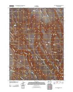
2011 Map of Dry Creek Bench
USGS Topo · Published 2011About this map
Dry Creek Bench dominates this high-desert landscape in Malheur County, where the management of scarce water resources is written into the names of the land. In this arid corner of eastern Oregon, a network of man-made catchments like Twelvemile Reservoir, Frenchys Reservoir, and Miracle Reservoir supports the region's ranching interests. The terrain is defined by a series of intermittent drainages, most notably Antelope Creek and the southern reaches of Fish Creek, which lead toward the distinct elevation of the bench. The presence of numerous named water sources, including Cherry Spring, Bench Spring, and Tin Trough Spring, highlights the critical points of survival and navigation for those moving through this remote territory. This mapping shows the distribution of reservoirs and springs as they existed early in the twenty-first century, providing a detailed look at the hydraulic infrastructure essential to this sagebrush-covered terrain.
Find a feature on this map
22 named features on this map. Tap any name to fly to it.
Don’t see what you’re looking for? This feature index may not catch every label — zoom into the map to look around manually.
Map Details
Editions of this 2011 Dry Creek Bench Map
This is the sole edition of this map. No revisions or reprints were ever made.
Other maps of this area

1955 · Jordan Valley
USGS Topo · 1:250,000

1955 · Adel
USGS Topo · 1:250,000

1957 · Adel
USGS Topo · 1:250,000

1957 · Jordan Valley
USGS Topo · 1:250,000

1958 · Adel
USGS Topo · 1:250,000

1958 · Jordan Valley
USGS Topo · 1:250,000

1962 · Adel
USGS Topo · 1:250,000
1981 · Twelvemile Ridge
USGS Topo · 1:24,000
1981 · Little Whitehorse Creek
USGS Topo · 1:24,000
1981 · Dry Creek Bench
USGS Topo · 1:24,000