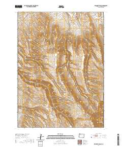
2020 Map of Dry Creek Bench
USGS Topo · Published 2020About this map
Dry Creek Bench dominates this high-desert landscape in Malheur County, where the management of water is clearly the primary concern for local land use. The map reveals a complex network of hydrological features, from the significant Twelvemile Reservoir and Miracle Reservoir to smaller, essential watering points like Cherry Spring and Tin Trough Spring. These sources feed a series of intermittent drainages including Twelvemile Cr and Little Antelope Cr, which carve through the terrain. Evidence of ranching operations and remote access is found along the northern and southern fringes via Echave Ranch Rd and Mud Spring Rd. The prevalence of named reservoirs, including Frenchus Reservoir and Fish Reservoir, highlights the vital role of water storage in this arid region of southeastern Oregon.
Find a feature on this map
28 named features on this map. Tap any name to fly to it.
Don’t see what you’re looking for? This feature index may not catch every label — zoom into the map to look around manually.
Map Details
Editions of this 2020 Dry Creek Bench Map
This is the sole edition of this map. No revisions or reprints were ever made.
Other maps of this area

1955 · Jordan Valley
USGS Topo · 1:250,000

1955 · Adel
USGS Topo · 1:250,000

1957 · Adel
USGS Topo · 1:250,000

1957 · Jordan Valley
USGS Topo · 1:250,000

1958 · Adel
USGS Topo · 1:250,000

1958 · Jordan Valley
USGS Topo · 1:250,000

1962 · Adel
USGS Topo · 1:250,000
1981 · Twelvemile Ridge
USGS Topo · 1:24,000
1981 · Little Whitehorse Creek
USGS Topo · 1:24,000
1981 · Dry Creek Bench
USGS Topo · 1:24,000