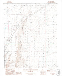
1986 Map of Dry Lake
USGS Topo · Published 1986About this map
The Moapa River Indian Reservation occupies the northern edge of this high-desert basin, where the Dry Lake Range separates two distinct drainage systems. The Dry Lake Valley to the west is dominated by the namesake Dry Lake and an adjacent Alkali Flat, characteristic of the endorheic basins found throughout this region. Transport and industrial activity are concentrated along the southwestern corridor, defined by the Union Pacific railroad and the highway marked 15. Here, the small settlement of Garnet and a Barrow Pit indicate local utility and resource extraction. The eastern portion of the map is defined by the broad California Wash, which carves through the arid landscape between the mountain slopes and the tribal boundary lines.
Find a feature on this map
17 named features on this map. Tap any name to fly to it.
Don’t see what you’re looking for? This feature index may not catch every label — zoom into the map to look around manually.
Map Details
Editions of this 1986 Dry Lake Map
This is the sole edition of this map. No revisions or reprints were ever made.
Other maps of this area

1886 · Saint Thomas
USGS Topo · 1:250,000

1893 · Saint Thomas
USGS Topo · 1:250,000

1926 · Boulder Canyon
USGS Topo · 1:96,000

1952 · Dry Lake
USGS Topo · 1:62,500

1953 · Muddy Peak
USGS Topo · 1:62,500

1954 · Las Vegas
USGS Topo · 1:250,000

1957 · Las Vegas
USGS Topo · 1:250,000

1958 · Arrow Canyon
USGS Topo · 1:62,500

1958 · Moapa
USGS Topo · 1:62,500

1959 · Las Vegas
USGS Topo · 1:250,000