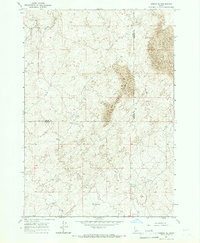
1964 Map of Dubois SE
USGS Topo · Published 1966About this map
Sand Dunes dominate the eastern landscape of this high-altitude interior region, showing the wind-sculpted topography of the Snake River Plain during the mid-1960s. The border between Clark Co and Fremont Co bisects the area, where the terrain shifts from shifting sands to a sparse network of water sources. Small-scale hydrologic features such as a Water Tank and scattered Wells indicate the critical importance of water management for livestock or seasonal land use in this arid environment. Navigation across this territory is defined by primitive infrastructure, primarily a rugged Jeep Trail that cuts through the open country. In the north, Camas Creek provides a natural landmark within a landscape otherwise defined by subtle elevation changes and the distinctive, shifting forms of the massive dune fields.
Find a feature on this map
6 named features on this map. Tap any name to fly to it.
Don’t see what you’re looking for? This feature index may not catch every label — zoom into the map to look around manually.
Map Details
Editions of this 1964 Dubois SE Map
This is the sole edition of this map. No revisions or reprints were ever made.
Other maps of this area

1951 · Plano
USGS Topo · 1:24,000

1955 · Dubois
USGS Topo · 1:250,000

1955 · Idaho Falls
USGS Topo · 1:250,000

1955 · Ashton
USGS Topo · 1:250,000

1955 · Driggs
USGS Topo · 1:250,000

1958 · Driggs
USGS Topo · 1:250,000

1958 · Dubois
USGS Topo · 1:250,000

1958 · Idaho Falls
USGS Topo · 1:250,000

1958 · Ashton
USGS Topo · 1:250,000

1960 · Ashton
USGS Topo · 1:250,000