
1962 Map of Dubuque
USGS Topo · Published 1962About this map
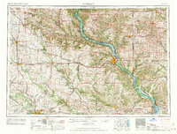
The Mississippi River valley anchors this early 1960s study of the Tri-State area, showing the convergence of Iowa, Wisconsin, and Illinois. The city of Dubuque serves as the regional hub, flanked by the sprawling Upper Mississippi National Wildlife Refuge. The landscape is defined by the Driftless Area's unique topography, including prominent landmarks like Sinsinawa Mound and Charles Mound.
Find a feature on this map
258 named features on this map. Tap any name to fly to it.
Don’t see what you’re looking for? This feature index may not catch every label — zoom into the map to look around manually.
Map Details
Editions of this 1962 Dubuque Map
2 editions found
Other maps of this area

1887 · Cedar Rapids
USGS Topo · 1:62,500

1888 · Shellsburg
USGS Topo · 1:62,500

1888 · Marion
USGS Topo · 1:62,500

1888 · Amana
USGS Topo · 1:62,500

1889 · Tipton
USGS Topo · 1:62,500

1889 · Marion
USGS Topo · 1:62,500

1889 · Amana
USGS Topo · 1:62,500

1889 · Shellsburg
USGS Topo · 1:62,500

1890 · Tipton
USGS Topo · 1:62,500

1890 · Anamosa
USGS Topo · 1:62,500