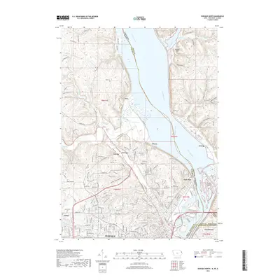
2018 Map of Dubuque North
USGS Topo · Published 2018About this map
The Mississippi River creates a natural boundary between Iowa and Wisconsin on this 2018 survey, where the river's path is marked by islands and lowlands like Stumpf Island and Peru Bottoms. The northern reach of Dubuque is visible, transitioning from dense urban street grids near Eagle Point to suburban developments in Asbury and Sageville. Significant land use is dedicated to historical burial grounds, including the large Linwood Cem and Mt Calvary Cem, which serve as vital points of reference for genealogists. The industrial and natural character of the riverbank is evidenced by the John Deere Marsh, while the surrounding terrain is defined by a series of deep ravines such as Fox Hollow and Union Park Hollow. This modern record illustrates the expansion of residential roads like Circle Ridge Rd and Whispering Ridge into the dissected uplands overlooking the Little Maquoketa River valley.
Find a feature on this map
211 named features on this map. Tap any name to fly to it.
Don’t see what you’re looking for? This feature index may not catch every label — zoom into the map to look around manually.
Map Details
Editions of this 2018 Dubuque North Map
This is the sole edition of this map. No revisions or reprints were ever made.
Other maps of this area

1900 · Lancaster
USGS Topo · 1:125,000

1901 · Peosta
USGS Topo · 1:125,000

1904 · Lancaster
USGS Topo · 1:125,000

1908 · Lancaster
USGS Topo · 1:125,000

1935 · East Dubuque
USGS Topo · 1:62,500

1940 · East Dubuque
USGS Topo · 1:62,500

1955 · Menominee
USGS Topo · 1:24,000

1955 · Dubuque South
USGS Topo · 1:24,000

1955 · Balltown
USGS Topo · 1:24,000

1956 · Dubuque North
USGS Topo · 1:24,000