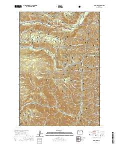
2020 Map of Duck Creek
USGS Topo · Published 2020About this map
The Imnaha Wild and Scenic River defines the northern reaches of this high-elevation terrain, where it flows through the Wallowa National Forest. This remote landscape straddles the border between Wallowa Co and Baker Co, transitioning southward into the Whitman National Forest. The map documents a rugged water network characterized by numerous drainages such as Lake Fork Cr, Duck Cr, and Dutchman Cr, which carve through the steep topography of the Wallowa Mountains.
Find a feature on this map
35 named features on this map. Tap any name to fly to it.
Don’t see what you’re looking for? This feature index may not catch every label — zoom into the map to look around manually.
Map Details
Editions of this 2020 Duck Creek Map
This is the sole edition of this map. No revisions or reprints were ever made.
Other maps of this area

1915 · Pine
USGS Topo · 1:125,000

1954 · Cornucopia
USGS Topo · 1:62,500

1955 · Baker
USGS Topo · 1:250,000

1955 · Grangeville
USGS Topo · 1:250,000

1957 · Halfway
USGS Topo · 1:62,500

1957 · Homestead
USGS Topo · 1:62,500

1957 · Copperfield
USGS Topo · 1:62,500

1959 · Baker
USGS Topo · 1:250,000

1959 · Grangeville
USGS Topo · 1:250,000

1980 · McCall
USGS Topo · 1:100,000