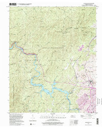
1999 Map of Ducktown
USGS Topo · Published 2001About this map
Industrial history and protected forest land meet in this late 20th-century survey of the Copper Basin. The Burra Burra Mine and Hiwassee Mine stand as prominent markers of the region's deep-rooted mining economy, situated near the settlement of Ducktown. The landscape is dominated by the Cherokee National Forest and the Little Frog Mountain Wilderness, which encompass peaks like Panther Knob and Sassatras Knob. The Ocoee River is heavily utilized for regional power, featuring the Ocoee No 2 Dam and Ocoee No 3 Dam, while the L & N RR provides the primary rail corridor for industrial and passenger transport. Smaller settlements like Postelle, Red Hill, and MeHarg are scattered across the terrain, connected by the 2 Lane River Road. Cultural landmarks such as Mt Zion Ch and Copper Basin High School anchor the local community between the river and the Tennessee-North Carolina border.
Find a feature on this map
78 named features on this map. Tap any name to fly to it.
Don’t see what you’re looking for? This feature index may not catch every label — zoom into the map to look around manually.
Map Details
Editions of this 1999 Ducktown Map
This is the sole edition of this map. No revisions or reprints were ever made.
Other maps of this area

1886 · Dalton
USGS Topo · 1:125,000

1886 · Cleveland
USGS Topo · 1:125,000

1888 · Ellijay
USGS Topo · 1:125,000

1892 · Cleveland
USGS Topo · 1:125,000

1892 · Ellijay
USGS Topo · 1:125,000

1892 · Dalton
USGS Topo · 1:125,000

1893 · Murphy
USGS Topo · 1:125,000

1895 · Cleveland
USGS Topo · 1:125,000

1897 · Dalton
USGS Topo · 1:125,000

1898 · Ellijay
USGS Topo · 1:125,000