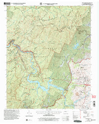
2003 Map of Ducktown
USGS Topo · Published 2004About this map
Burra Burra Mine and the Hiwassee Mine anchor the landscape around Ducktown, reflecting the deep industrial roots of the Copper Basin in Polk County. This 2003 revision by the USDA Forest Service highlights a region defined by its rugged geography and the massive Ocoee No 3 Lake reservoir system. The map captures the infrastructure of the Ocoee River, including the Ocoee No 3 Powerhouse and the Ocoee Whitewater Center, which became famous for hosting international competitions. Away from the water, the terrain is dominated by the Little Frog Wilderness and high points like Smith Mountain. Local history is preserved in family-named landmarks such as Jenkins Grave and Hedden Grave, while the L & N RR follows the bends of the river, serving as the historical backbone for hauling minerals from the Boyd Mine.
Find a feature on this map
81 named features on this map. Tap any name to fly to it.
Don’t see what you’re looking for? This feature index may not catch every label — zoom into the map to look around manually.
Map Details
Editions of this 2003 Ducktown Map
This is the sole edition of this map. No revisions or reprints were ever made.
Other maps of this area

1886 · Dalton
USGS Topo · 1:125,000

1886 · Cleveland
USGS Topo · 1:125,000

1888 · Ellijay
USGS Topo · 1:125,000

1892 · Cleveland
USGS Topo · 1:125,000

1892 · Ellijay
USGS Topo · 1:125,000

1892 · Dalton
USGS Topo · 1:125,000

1893 · Murphy
USGS Topo · 1:125,000

1895 · Cleveland
USGS Topo · 1:125,000

1897 · Dalton
USGS Topo · 1:125,000

1898 · Ellijay
USGS Topo · 1:125,000