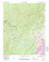
1957 Map of Ducktown
USGS Topo · Published 1991About this map
Ducktown and the surrounding Copper Basin define this landscape, where industrial mining and hydroelectric engineering intersect with the Cherokee National Forest. The map documents a dense concentration of mineral extraction sites, including the Burra Burra Mine, Boyd Mine, and the Old Tennessee Mine, all served by the L & N RR. This industrial footprint is contrasted by the protected lands of the Ocoee Wildlife Management Area and the Little Frog Mountain ridge.
Find a feature on this map
89 named features on this map. Tap any name to fly to it.
Don’t see what you’re looking for? This feature index may not catch every label — zoom into the map to look around manually.
Map Details
Editions of this 1957 Ducktown Map
4 editions found
Other maps of this area

1886 · Dalton
USGS Topo · 1:125,000

1886 · Cleveland
USGS Topo · 1:125,000

1888 · Ellijay
USGS Topo · 1:125,000

1892 · Cleveland
USGS Topo · 1:125,000

1892 · Ellijay
USGS Topo · 1:125,000

1892 · Dalton
USGS Topo · 1:125,000

1893 · Murphy
USGS Topo · 1:125,000

1895 · Cleveland
USGS Topo · 1:125,000

1897 · Dalton
USGS Topo · 1:125,000

1898 · Ellijay
USGS Topo · 1:125,000