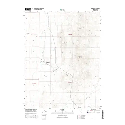
2014 Map of Duckwater
USGS Topo · Published 2014About this map
Duckwater serves as the focal point of this Nevada landscape, situated within the broad Duckwater Valley where water sources like Big Warm Spring and Little Warm Spring support local life in a desert environment. The settlement pattern is defined by a network of local thoroughfares, including Newe St, Sugarshack Rd, and Duckwater Rd, which link the main community to the outlying Collins Meadow. To the east, the topography shifts abruptly into the Duckwater Hills, providing a stark contrast to the riparian corridor of Duckwater Cr. For those researching local families, the Duckwater Cemetery is clearly marked at the southern end of the valley, while the presence of Old Collins Spring and the Brown Summit Truck Trl suggest long-established patterns of movement through the Great Basin terrain.
Find a feature on this map
20 named features on this map. Tap any name to fly to it.
Don’t see what you’re looking for? This feature index may not catch every label — zoom into the map to look around manually.
Map Details
Editions of this 2014 Duckwater Map
This is the sole edition of this map. No revisions or reprints were ever made.
Other maps of this area

1951 · Green Springs
USGS Topo · 1:62,500

1956 · Lund
USGS Topo · 1:250,000

1956 · Ely
USGS Topo · 1:250,000

1959 · Ely
USGS Topo · 1:250,000

1960 · Lund
USGS Topo · 1:250,000

1963 · Ely
USGS Topo · 1:250,000

1964 · Duckwater
USGS Topo · 1:62,500

1964 · Moody Peak
USGS Topo · 1:62,500

1968 · Brown Summit
USGS Topo · 1:24,000
1968 · Sand Spring
USGS Topo · 1:24,000