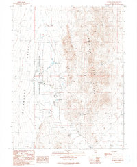
1990 Map of Duckwater
USGS Topo · Published 1990About this map
The Duckwater Indian Reservation occupies much of this high desert terrain in Nye County, centered around the settlement of Duckwater. Water is the lifeblood of this landscape, evidenced by a series of geothermal and natural features including Big Warm Spring, Little Warm Spring, and Old Collins Spring. These sources feed into Duckwater Creek and the lush Collins Meadow, supporting local agriculture and livestock indicated by several corral sites. This 1990 edition captures the community infrastructure of the era, from the Duckwater Sch and Athletic Field to essential utilities like the Sewage Disposal Ponds and a Radio Tower. The geography is bounded to the east by the rising Duckwater Hills, while man-made water management systems such as the Aqueduct and various ditch lines illustrate the ongoing effort to direct flow through the arid valley floor.
Find a feature on this map
26 named features on this map. Tap any name to fly to it.
Don’t see what you’re looking for? This feature index may not catch every label — zoom into the map to look around manually.
Map Details
Editions of this 1990 Duckwater Map
This is the sole edition of this map. No revisions or reprints were ever made.
Other maps of this area

1951 · Green Springs
USGS Topo · 1:62,500

1956 · Lund
USGS Topo · 1:250,000

1956 · Ely
USGS Topo · 1:250,000

1959 · Ely
USGS Topo · 1:250,000

1960 · Lund
USGS Topo · 1:250,000

1963 · Ely
USGS Topo · 1:250,000

1964 · Duckwater
USGS Topo · 1:62,500

1964 · Moody Peak
USGS Topo · 1:62,500

1968 · Brown Summit
USGS Topo · 1:24,000
1968 · Sand Spring
USGS Topo · 1:24,000