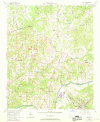
1956 Map of Duluth
USGS Topo · Published 1969About this map
The Chattahoochee River serves as the southern border of this landscape, separating Fulton and Gwinnett counties while supporting a network of early crossings including Abbotts Bridge and Rogers Bridge Road. The interior of the quadrangle is characterized by a high density of rural community centers, many defined by their local congregations and schoolhouses. Places like Ocee and Warsaw appear as established rural nodes, with the commercial center of Duluth anchored by the Southern Railway at the map's southeastern corner. This survey also records numerous rural cemeteries and small churches, such as Macedonia Ch and Union Hill Ch, which reflect the localized settlement patterns before modern suburban development. The presence of the County Waterworks near the river indicates the early infrastructure supporting the growth of these Georgia communities in the mid-20th century.
Find a feature on this map
63 named features on this map. Tap any name to fly to it.
Don’t see what you’re looking for? This feature index may not catch every label — zoom into the map to look around manually.
Map Details
Editions of this 1956 Duluth Map
4 editions found
Other maps of this area

1888 · Atlanta
USGS Topo · 1:125,000

1890 · Suwanee
USGS Topo · 1:125,000

1890 · Atlanta
USGS Topo · 1:125,000

1892 · Atlanta
USGS Topo · 1:125,000

1894 · Suwanee
USGS Topo · 1:125,000

1895 · Atlanta
USGS Topo · 1:125,000

1953 · Atlanta
USGS Topo · 1:250,000

1954 · Chamblee
USGS Topo · 1:24,000

1955 · Rome
USGS Topo · 1:250,000

1956 · Duluth
USGS Topo · 1:24,000