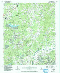
1992 Map of Duluth
USGS Topo · Published 1993About this map
The Chattahoochee River forms a natural boundary between Fulton and Gwinnett counties, anchored by the community of Duluth. By the early 1990s, the landscape reflects significant suburban transition, with established residential grids appearing near Alpharetta and the Lake Windward area. Despite this growth, older rural markers remain visible, including numerous community churches such as Union Hill Ch and Cross Plains Ch, alongside family-named landmarks like James Cem.
Find a feature on this map
43 named features on this map. Tap any name to fly to it.
Don’t see what you’re looking for? This feature index may not catch every label — zoom into the map to look around manually.
Map Details
Editions of this 1992 Duluth Map
This is the sole edition of this map. No revisions or reprints were ever made.
Other maps of this area

1888 · Atlanta
USGS Topo · 1:125,000

1890 · Suwanee
USGS Topo · 1:125,000

1890 · Atlanta
USGS Topo · 1:125,000

1892 · Atlanta
USGS Topo · 1:125,000

1894 · Suwanee
USGS Topo · 1:125,000

1895 · Atlanta
USGS Topo · 1:125,000

1953 · Atlanta
USGS Topo · 1:250,000

1954 · Chamblee
USGS Topo · 1:24,000

1955 · Rome
USGS Topo · 1:250,000

1956 · Duluth
USGS Topo · 1:24,000