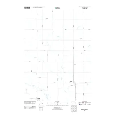
2013 Map of Dumont North
USGS Topo · Published 2013About this map
Agricultural production and the drainage patterns of the Cedar River basin define this portion of Butler County. The landscape is structured by a precise grid of rural routes including Clay Ave and Grand Ave, which serve the large-scale farming operations that anchor the local economy. Specific named agricultural sites such as Reser Farms, Poelma Dairy, and Umble Hog Farm illustrate the region's specialization in dairy and livestock at the start of the 21st century. The settlement of Bristow occupies a central position near the intersection of Main St and Church St, while the northern edge of Dumont appears in the southwest corner along the W Fork Cedar River. Watercourses like Parmentar Cr and Boylan Cr meander through the fields, following the natural contours of the land in contrast to the rigid geometry of the surrounding road network.
Find a feature on this map
43 named features on this map. Tap any name to fly to it.
Don’t see what you’re looking for? This feature index may not catch every label — zoom into the map to look around manually.
Map Details
Editions of this 2013 Dumont North Map
This is the sole edition of this map. No revisions or reprints were ever made.
Other maps of this area

1954 · Waterloo
USGS Topo · 1:250,000

1955 · Waterloo
USGS Topo · 1:250,000

1972 · Dumont North
USGS Topo · 1:24,000

1972 · Hansell
USGS Topo · 1:24,000
1972 · Dougherty
USGS Topo · 1:24,000
1972 · Aureola
USGS Topo · 1:24,000

1972 · Allison
USGS Topo · 1:24,000
1972 · Greene
USGS Topo · 1:24,000

1979 · Ackley NE
USGS Topo · 1:24,000

1979 · Dumont South
USGS Topo · 1:24,000