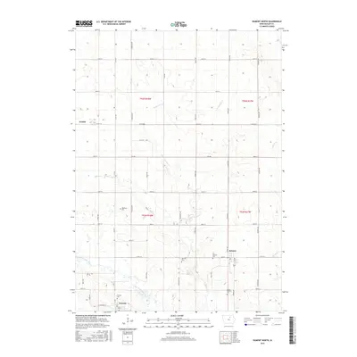
2015 Map of Dumont North
USGS Topo · Published 2015About this map
The West Fork Cedar River carves through the southern landscape of this Butler County region, defining the drainage patterns for a network of prairie tributaries like Boylan Cr and Parmentar Cr. The agricultural grid of Butler County is punctuated by the established settlements of Bristow, Aredale, and the northern edge of Dumont. These communities serve as the anchors for a rural landscape where local history is preserved in numerous burial grounds, including the Old Bristow Cem and South Bristow Cem near the town center, and the more isolated Needham Cem and Oak Hill Cem. The road network, from Main St in Bristow to the various county roads like Co Rd C33, illustrates the connectivity between these small farming hubs and their surrounding fields in the early twenty-first century.
Find a feature on this map
31 named features on this map. Tap any name to fly to it.
Don’t see what you’re looking for? This feature index may not catch every label — zoom into the map to look around manually.
Map Details
Editions of this 2015 Dumont North Map
This is the sole edition of this map. No revisions or reprints were ever made.
Other maps of this area

1954 · Waterloo
USGS Topo · 1:250,000

1955 · Waterloo
USGS Topo · 1:250,000

1972 · Dumont North
USGS Topo · 1:24,000

1972 · Hansell
USGS Topo · 1:24,000
1972 · Dougherty
USGS Topo · 1:24,000
1972 · Aureola
USGS Topo · 1:24,000

1972 · Allison
USGS Topo · 1:24,000
1972 · Greene
USGS Topo · 1:24,000

1979 · Ackley NE
USGS Topo · 1:24,000

1979 · Dumont South
USGS Topo · 1:24,000