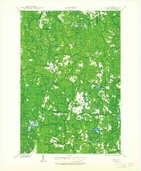
1939 Map of Dunbar
USGS Topo · Published 1965About this map
The timber and rail landscape of northern Marinette County is documented here as it stood just before the mid-century, centered on the village of Dunbar. This area is defined by the heavy presence of the Minneapolis St Paul and Sault Ste Marie RR, which facilitated the movement of resources through the northern Wisconsin woods. The settlement of Merriman and numerous rural educational sites, such as Pike Ridge Sch and Merriman Sch, suggest a once-active community structure built around localized schools and small-scale river crossings.
Find a feature on this map
65 named features on this map. Tap any name to fly to it.
Don’t see what you’re looking for? This feature index may not catch every label — zoom into the map to look around manually.
Map Details
Editions of this 1939 Dunbar Map
2 editions found
Other maps of this area

1939 · Pembine
USGS Topo · 1:48,000

1939 · Dunbar
USGS Topo · 1:48,000

1939 · Goodman
USGS Topo · 1:48,000

1939 · Iron Mountain
USGS Topo · 1:48,000

1940 · Thunder Mtn.
USGS Topo · 1:48,000

1940 · Athelstane
USGS Topo · 1:48,000

1941 · Florence
USGS Topo · 1:48,000

1941 · Dunbar
USGS Topo · 1:48,000

1941 · Iron Mountain
USGS Topo · 1:48,000

1942 · Athelstane
USGS Topo · 1:48,000