1939 Map of Dunbar
USGS Topo · Published 1955About this map
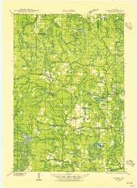
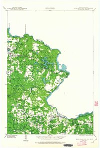
The town of Dunbar serves as the central hub of this 1939 survey of northern Wisconsin, positioned along the tracks of the Minneapolis St Paul and Sault Ste Marie railroad. The landscape is defined by the South Branch Pemebonwon River and the North Branch Pike River, winding through a territory dotted with rural schoolhouses that speak to the local education system of the early twentieth century. These include McKinley Sch, Pike Ridge Sch, and Merriman Sch. Small settlements like Belgian and Merriman are connected by the County Highway and various forest routes such as Crossett Rd. The topography is marked by numerous water bodies like Lake Lundgren and Woempner Lake, while the Dunbar Fire Tower provides a fixed landmark for forest management. This era in Marinette County shows a balance of logging-related transit and establishing rural communities.
Find a feature on this map
65 named features on this map. Tap any name to fly to it.
Don’t see what you’re looking for? This feature index may not catch every label — zoom into the map to look around manually.
Map Details
Editions of this 1939 Dunbar Map
2 editions found
Other maps of this area
1939 · Pembine
USGS Topo · 1:48,000
1939 · Goodman
USGS Topo · 1:48,000
1939 · Iron Mountain
USGS Topo · 1:48,000
1940 · Thunder Mtn.
USGS Topo · 1:48,000

1940 · Athelstane
USGS Topo · 1:48,000

1941 · Florence
USGS Topo · 1:48,000
1941 · Dunbar
USGS Topo · 1:48,000

1941 · Iron Mountain
USGS Topo · 1:48,000

1942 · Athelstane
USGS Topo · 1:48,000
1942 · Wausaukee
USGS Topo · 1:48,000