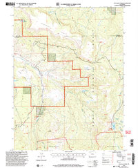
2000 Map of Dunckley Pass
USGS Topo · Published 2004About this map
Routt National Forest dominates this high-altitude landscape along the border of Routt and Rio Blanco counties. The terrain is characterized by the expansive Dunckley Flat Tops and significant water management features, including Sheriff Reservoir, Haley Reservoir, and Gill Reservoir. The survey captures a moment in the early 2000s when the Flat Tops Scenic Byway traversed the heights, passing through Dunckley Pass to connect the high plateaus. The drainage patterns of the East Fork Williams Fork and Trout Creek define the deep basins below Egry Mesa. In the southern reaches, the map transitions into the protected Flat Tops Wilderness, showing a landscape shaped by both natural volcanic geology and the water infrastructure required for the region's ranching and conservation needs. Significant peaks like Baldy Mountain serve as primary landmarks for navigating the complex network of forest roads and trails that intersect the wilderness boundary.
Find a feature on this map
27 named features on this map. Tap any name to fly to it.
Don’t see what you’re looking for? This feature index may not catch every label — zoom into the map to look around manually.
Map Details
Editions of this 2000 Dunckley Pass Map
This is the sole edition of this map. No revisions or reprints were ever made.
Other maps of this area

1916 · Daton Peak
USGS Topo · 1:62,500

1920 · Daton Peak
USGS Topo · 1:62,500

1924 · Mt. Harris
USGS Topo · 1:48,000

1926 · Mount Harris
USGS Topo · 1:62,500

1954 · Craig
USGS Topo · 1:250,000

1957 · Craig
USGS Topo · 1:250,000

1958 · Craig
USGS Topo · 1:250,000

1960 · Craig
USGS Topo · 1:250,000

1962 · Craig
USGS Topo · 1:250,000

1964 · Craig
USGS Topo · 1:250,000