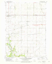
1978 Map of Duncombe
USGS Topo · Published 1979About this map
The town of Duncombe serves as a central hub in this late 1970s landscape, situated at the intersection of the Illinois Central Gulf railroad and local thoroughfares. This agricultural region is defined by an intricate network of drainage systems, including No 11 Ditch and No 4 Ditch, which manage the water table across the Colfax and Washington townships. To the south, the terrain shifts towards the conservation lands of Brushy Creek State Park, where the winding course of Brushy Creek and a Flowing Well offer a contrast to the geometric precision of the surrounding section lines.
Find a feature on this map
25 named features on this map. Tap any name to fly to it.
Don’t see what you’re looking for? This feature index may not catch every label — zoom into the map to look around manually.
Map Details
Editions of this 1978 Duncombe Map
This is the sole edition of this map. No revisions or reprints were ever made.
Other maps of this area

1923 · Lehigh
USGS Topo · 1:62,500

1923 · Fort Dodge
USGS Topo · 1:62,500

1954 · Waterloo
USGS Topo · 1:250,000

1954 · Fort Dodge
USGS Topo · 1:250,000

1955 · Waterloo
USGS Topo · 1:250,000

1957 · Fort Dodge
USGS Topo · 1:250,000

1958 · Fort Dodge
USGS Topo · 1:250,000

1965 · Lehigh
USGS Topo · 1:24,000

1965 · Evanston
USGS Topo · 1:24,000

1978 · Woolstock
USGS Topo · 1:24,000