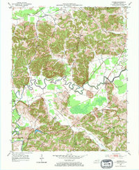
1953 Map of Dundee
USGS Topo · Published 1967About this map
The winding loops of the Rough River dominate this mid-century portrait of Ohio County, where the landscape is defined by a dense network of country churches, family cemeteries, and active petroleum extraction. Small agricultural and social centers like Dundee and Sulphur Springs anchor the community, surrounded by several family-named landmarks such as Ralph Chapel and Marvins Chapel. The map reveals a high concentration of oil wells and designated oil fields particularly north of the river, indicating the importance of the local energy industry during this era.
Find a feature on this map
45 named features on this map. Tap any name to fly to it.
Don’t see what you’re looking for? This feature index may not catch every label — zoom into the map to look around manually.
Map Details
Editions of this 1953 Dundee Map
2 editions found
Other maps of this area

1907 · Whitesville
USGS Topo · 1:62,500

1909 · Whitesville
USGS Topo · 1:62,500

1909 · Hartford
USGS Topo · 1:62,500

1925 · Spring Lick
USGS Topo · 1:62,500

1932 · Fordsville
USGS Topo · 1:62,500

1953 · Philpot
USGS Topo · 1:24,000

1953 · Dundee
USGS Topo · 1:24,000

1953 · Whitesville
USGS Topo · 1:24,000

1953 · Pleasant Ridge
USGS Topo · 1:24,000
1953 · Fordsville
USGS Topo · 1:24,000