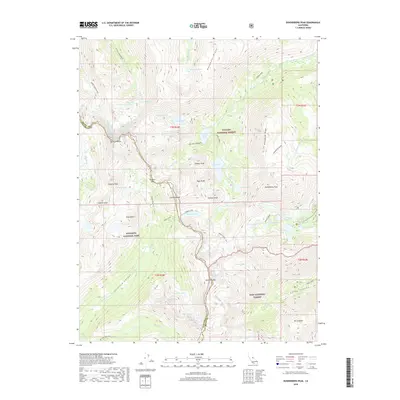
2018 Map of Dunderberg Peak
USGS Topo · Published 2018About this map
Yosemite National Park shares its high-elevation boundary with two other major preserves in this eastern Sierra Nevada study, meeting the Toiyabe National Forest and Inyo National Forest along the rugged crest. The map illustrates a glaciated landscape defined by granite summits and high-altitude water bodies, centered on the Virginia Lakes basin. Historical access routes like the Virginia Pass Trail and the McCabe Lakes Trail navigate the steep transitions between basins, crossing the divide at Virginia Pass and Summit Pass. Significant peaks such as Dunderberg Peak and Excelsior Mtn dominate the skyline, overlooking a dense concentration of subalpine lakes including Hunewill Lake, Trumbull Lake, and the Hoover Lakes. The terrain is marked by dramatic vertical relief, from the depths of Lundy Canyon to the exposed ridges of Monument Ridge and Kavanaugh Ridge.
Find a feature on this map
70 named features on this map. Tap any name to fly to it.
Don’t see what you’re looking for? This feature index may not catch every label — zoom into the map to look around manually.
Map Details
Editions of this 2018 Dunderberg Peak Map
This is the sole edition of this map. No revisions or reprints were ever made.
Other maps of this area

1901 · Mt. Lyell
USGS Topo · 1:125,000

1909 · Bridgeport
USGS Topo · 1:125,000

1911 · Bridgeport
USGS Topo · 1:125,000

1920 · Bridgeport
USGS Topo · 1:125,000

1947 · Mariposa
USGS Topo · 1:250,000

1948 · Walker Lake
USGS Topo · 1:250,000

1948 · Mariposa
USGS Topo · 1:250,000

1953 · Mono Craters
USGS Topo · 1:62,500

1956 · Matterhorn Peak
USGS Topo · 1:62,500

1956 · Tuolumne Meadows
USGS Topo · 1:62,500