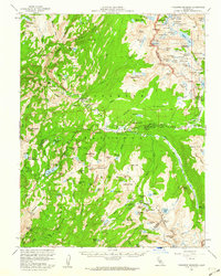
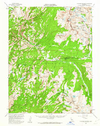
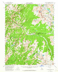
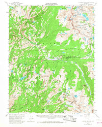
1956 Map of Tuolumne Meadows
USGS Topo · Published 1960About this map
Yosemite National Park and the adjacent Inyo National Forest define this high-altitude landscape during the mid-1950s. The network of Tuolumne Meadows High Sierra Camp, Glen Aulin High Sierra Camp, and Vogelsang High Sierra Camp illustrates the established backcountry infrastructure of the era, centered around Parsons Memorial Lodge. The terrain is dominated by iconic granite formations like Cathedral Peak, Fairview Dome, and the Cathedral Ridge, which separate the myriad glacial basins. The eastern edge of the map reveals the industrial history of the High Sierra, showing the Fahntail Mine and a mill near the Mono and Tuolumne County line. The path of Tioga Road serves as the primary artery through Dana Meadows, providing access to numerous water bodies such as Saddlebag Lake and Tioga Lake.
Find a feature on this map
155 named features on this map. Tap any name to fly to it.
Don’t see what you’re looking for? This feature index may not catch every label — zoom into the map to look around manually.
Map Details
Editions of this 1956 Tuolumne Meadows Map
5 editions found

Other maps of this area

1896 · Dardanelles
USGS Topo · 1:125,000

1897 · Yosemite
USGS Topo · 1:125,000

1898 · Dardanelles
USGS Topo · 1:125,000

1900 · Yosemite
USGS Topo · 1:125,000

1901 · Mt. Lyell
USGS Topo · 1:125,000

1903 · Yosemite
USGS Topo · 1:125,000

1909 · Yosemite
USGS Topo · 1:125,000

1909 · Bridgeport
USGS Topo · 1:125,000

1911 · Bridgeport
USGS Topo · 1:125,000

1920 · Bridgeport
USGS Topo · 1:125,000