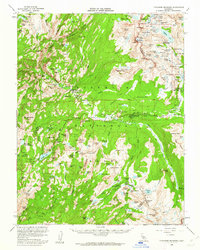
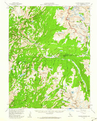
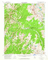
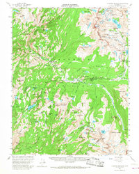
1956 Map of Tuolumne Meadows
USGS Topo · Published 1962About this map
Yosemite National Park dominates this mid-century survey, revealing a landscape defined by high-altitude meadows and a specialized network of wilderness camps. The presence of the Glen Aulin, Tuolumne Meadows, and Vogelsang high sierra camps highlights a unique era of backcountry recreation where permanent tent sites supported hikers along the Sunrise Trail and John Muir Trail. In the northern section, the Bennettville (Site) and the Great Sierra Mine serve as reminders of the area's silver mining attempts before the land was fully dedicated to federal protection.
Find a feature on this map
144 named features on this map. Tap any name to fly to it.
Don’t see what you’re looking for? This feature index may not catch every label — zoom into the map to look around manually.
Map Details
Editions of this 1956 Tuolumne Meadows Map
5 editions found

Other maps of this area

1896 · Dardanelles
USGS Topo · 1:125,000

1897 · Yosemite
USGS Topo · 1:125,000

1898 · Dardanelles
USGS Topo · 1:125,000

1900 · Yosemite
USGS Topo · 1:125,000

1901 · Mt. Lyell
USGS Topo · 1:125,000

1903 · Yosemite
USGS Topo · 1:125,000

1909 · Yosemite
USGS Topo · 1:125,000

1909 · Bridgeport
USGS Topo · 1:125,000

1911 · Bridgeport
USGS Topo · 1:125,000

1920 · Bridgeport
USGS Topo · 1:125,000