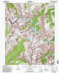
1994 Map of Dunderberg Peak
USGS Topo · Published 1997About this map
Yosemite National Park and the Hoover Wilderness meet at the high crests of the Sierra Nevada in this mid-1990s survey. The landscape is defined by the sharp divide between Mono and Tuolumne counties, where massive formations like Dunderberg Peak and Excelsior Mountain tower over glacial basins. The drainage patterns are clearly marked, with Virginia Creek and Green Creek flowing through complex alpine lake systems including East Lake, Lundy Lake, and the remote Summit Lake.
Find a feature on this map
42 named features on this map. Tap any name to fly to it.
Don’t see what you’re looking for? This feature index may not catch every label — zoom into the map to look around manually.
Map Details
Editions of this 1994 Dunderberg Peak Map
This is the sole edition of this map. No revisions or reprints were ever made.
Other maps of this area

1901 · Mt. Lyell
USGS Topo · 1:125,000

1909 · Bridgeport
USGS Topo · 1:125,000

1911 · Bridgeport
USGS Topo · 1:125,000

1920 · Bridgeport
USGS Topo · 1:125,000

1947 · Mariposa
USGS Topo · 1:250,000

1948 · Walker Lake
USGS Topo · 1:250,000

1948 · Mariposa
USGS Topo · 1:250,000

1953 · Mono Craters
USGS Topo · 1:62,500

1956 · Matterhorn Peak
USGS Topo · 1:62,500

1956 · Tuolumne Meadows
USGS Topo · 1:62,500