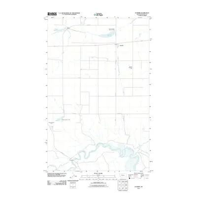
2011 Map of Dunkirk
USGS Topo · Published 2011About this map
The Marias River meanders across the southern portion of this high plains landscape, defining the local topography as it flows past F Bridge. This 2011 survey captures the agricultural and water-management infrastructure of Toole County, where the small community of Dunkirk serves as a central point for a grid of rural roads including Hawkins Rd and Dobyns Rd. The area is characterized by several water storage projects essential to the local economy, most notably Melcott Reservoir and Dunkirk Reservoir. The presence of the G N R R Dunkirk Reservoir Dam points to the historical role of the Great Northern Railroad in shaping the region's development. Smaller-scale private and local efforts are reflected in features like the German Reservoir Dam and Wilson Number 1 Dam, which illustrate the complex network of irrigation and stock ponds used to manage this semi-arid environment.
Find a feature on this map
18 named features on this map. Tap any name to fly to it.
Don’t see what you’re looking for? This feature index may not catch every label — zoom into the map to look around manually.
Map Details
Editions of this 2011 Dunkirk Map
This is the sole edition of this map. No revisions or reprints were ever made.
Other maps of this area

1920 · Conrad
USGS Topo · 1:125,000

1943 · Antelope Coulee
USGS Topo · 1:62,500

1943 · Shelby
USGS Topo · 1:62,500

1954 · Shelby
USGS Topo · 1:250,000

1958 · Shelby
USGS Topo · 1:250,000

1967 · Central School
USGS Topo · 1:24,000

1967 · Naismith
USGS Topo · 1:24,000

1967 · Conrad Butte
USGS Topo · 1:24,000

1967 · South Devon School
USGS Topo · 1:24,000

1967 · Dunkirk
USGS Topo · 1:24,000