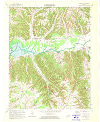
1970 Map of Dunnville
USGS Topo · Published 1972About this map
Green River Lake dominates the central landscape of this 1970 revision, showing the expanded waters of the reservoir as they meet the winding course of the Green River. The topography is defined by a series of prominent ridges, including Barnett Ridge and Millerfield Ridge, which separate the various creek valleys. Small rural communities like Pellyton and Dunnville serve as local hubs, connected by the Patton Road and Millerfield Road. The map provides significant detail for genealogists, pinpointing numerous family-named cemeteries and rural congregations such as Barnett Creek Ch, Jones Cem, and Pelley Cem. Along the eastern edge near Thomastown, the presence of Oil Wells indicates local resource extraction, while the Wilson Sch stands as a marker of the area's educational history. The three-way boundary intersection of Adair, Casey, and Russell counties adds a layer of jurisdictional complexity to this central Kentucky landscape.
Find a feature on this map
47 named features on this map. Tap any name to fly to it.
Don’t see what you’re looking for? This feature index may not catch every label — zoom into the map to look around manually.
Map Details
Editions of this 1970 Dunnville Map
This is the sole edition of this map. No revisions or reprints were ever made.
Other maps of this area

1952 · Clementsville
USGS Topo · 1:24,000

1952 · Liberty
USGS Topo · 1:24,000

1952 · Mannsville
USGS Topo · 1:24,000

1953 · Phil
USGS Topo · 1:24,000

1953 · Montpelier
USGS Topo · 1:24,000

1953 · Dunnville
USGS Topo · 1:24,000

1954 · Knifley
USGS Topo · 1:24,000

1954 · Russell Springs
USGS Topo · 1:24,000

1954 · Eli
USGS Topo · 1:24,000

1957 · Winchester
USGS Topo · 1:250,000