
1952 Map of Mannsville
USGS Topo · Published 1954About this map
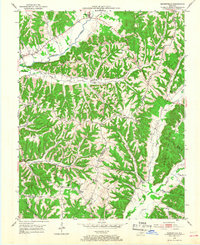
Mannsville serves as a northern anchor in this 1952 topographic study, situated along the winding course of Robinson Creek. The landscape is defined by a dense network of ridges, including Gaddis Ridge and Bass Ridge, which separate the various hollows and creek beds that supported small rural communities. The map highlights a high density of local institutions, from the Beech Grove Sch to churches like the Stoner Creek Ch and Christie Chapel, illustrating the social fabric of the Taylor and Casey County borderlands at mid-century.
Find a feature on this map
59 named features on this map. Tap any name to fly to it.
Don’t see what you’re looking for? This feature index may not catch every label — zoom into the map to look around manually.
Map Details
Editions of this 1952 Mannsville Map
2 editions found
Other maps of this area

1952 · Clementsville
USGS Topo · 1:24,000

1952 · Bradfordsville
USGS Topo · 1:24,000

1953 · Campbellsville
USGS Topo · 1:24,000

1953 · Bradfordsville NE
USGS Topo · 1:24,000

1953 · Spurlington
USGS Topo · 1:24,000

1953 · Dunnville
USGS Topo · 1:24,000

1953 · Cane Valley
USGS Topo · 1:24,000

1953 · Bradfordsville
USGS Topo · 1:24,000

1954 · Knifley
USGS Topo · 1:24,000

1957 · Winchester
USGS Topo · 1:250,000