
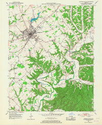
1953 Map of Campbellsville
USGS Topo · Published 1954About this map
Campbellsville serves as the central hub of this mid-century survey, showing the city's concentrated residential grid and essential infrastructure like the City Reservoir and the Fairgrounds. The landscape is defined by the Louisville and Nashville railroad corridor, which fueled the local economy alongside numerous educational and religious centers. Rural life in Taylor County is documented through a dense network of country schools and churches, including Taylor Co Sch, Wee Yan Sch, and Old Pitman Ch. To the south, the topography shifts toward the winding Robinson Creek and the Green River, where the terrain becomes more dissected with ridges like Smith Ridge and narrow hollows such as Cabin Hollow. The map provides a detailed view of the transition from an urbanizing county seat to the agricultural and forested lands along the Adair County border.
Find a feature on this map
62 named features on this map. Tap any name to fly to it.
Don’t see what you’re looking for? This feature index may not catch every label — zoom into the map to look around manually.
Map Details
Editions of this 1953 Campbellsville Map
2 editions found
Other maps of this area

1952 · Mannsville
USGS Topo · 1:24,000

1952 · Bradfordsville
USGS Topo · 1:24,000

1953 · Saloma
USGS Topo · 1:24,000

1953 · Gresham
USGS Topo · 1:24,000

1953 · Spurlington
USGS Topo · 1:24,000

1953 · Cane Valley
USGS Topo · 1:24,000

1953 · Bradfordsville
USGS Topo · 1:24,000

1954 · Knifley
USGS Topo · 1:24,000

1954 · Greensburg
USGS Topo · 1:24,000

1957 · Winchester
USGS Topo · 1:250,000