
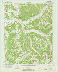
1953 Map of Phil
USGS Topo · Published 1954About this map
Hacker Ridge and Thomas Ridge define the intricate topography of this region during the early 1950s. The settlement of Phil serves as a central point, supported by smaller locales like Teddy, Evona, and Labascus. The landscape is heavily marked by rural community centers, particularly schools and churches that highlight a decentralized social structure, such as Centennial Sch, Chadwell Sch, and Canaan Valley Ch.
Find a feature on this map
75 named features on this map. Tap any name to fly to it.
Don’t see what you’re looking for? This feature index may not catch every label — zoom into the map to look around manually.
Map Details
Editions of this 1953 Phil Map
2 editions found
Other maps of this area

1952 · Clementsville
USGS Topo · 1:24,000

1952 · Liberty
USGS Topo · 1:24,000

1952 · Yosemite
USGS Topo · 1:24,000

1953 · Mintonville
USGS Topo · 1:24,000

1953 · Dunnville
USGS Topo · 1:24,000

1954 · Russell Springs
USGS Topo · 1:24,000

1954 · Eli
USGS Topo · 1:24,000
1954 · Faubush
USGS Topo · 1:24,000

1957 · Winchester
USGS Topo · 1:250,000

1960 · Winchester
USGS Topo · 1:250,000