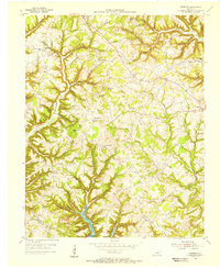
1954 Map of Faubush
USGS Topo · Published 1956About this map
The ridge-and-hollow terrain of western Pulaski County is deeply dissected here by Wolf Creek and Faubush Creek as they drain south into the recently formed Lake Cumberland. Published in the mid-1950s, the map documents the landscape shortly after the controlled inundation of the valley floors, showing the intricate shoreline that reshaped local access. The settlement of Faubush sits at a central crossroads, surrounded by a network of rural institutions that define the social geography of the era, including Lorenze Sch and Chester View Ch.
Find a feature on this map
99 named features on this map. Tap any name to fly to it.
Don’t see what you’re looking for? This feature index may not catch every label — zoom into the map to look around manually.
Map Details
Editions of this 1954 Faubush Map
This is the sole edition of this map. No revisions or reprints were ever made.
Other maps of this area

1911 · Monticello
USGS Topo · 1:62,500

1914 · Monticello
USGS Topo · 1:62,500

1932 · Burnside
USGS Topo · 1:62,500

1935 · Somerset
USGS Topo · 1:62,500

1953 · Phil
USGS Topo · 1:24,000

1953 · Frazer
USGS Topo · 1:24,000

1953 · Mintonville
USGS Topo · 1:24,000

1953 · Mill Springs
USGS Topo · 1:24,000

1954 · Jabez
USGS Topo · 1:24,000

1954 · Delmer
USGS Topo · 1:24,000