
1953 Map of Frazer
USGS Topo · Published 1955About this map
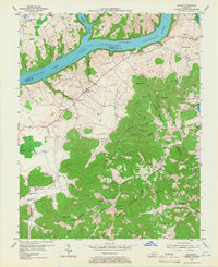
Lake Cumberland dominates the northern landscape of this mid-century survey, where the Cumberland River and Fishing Creek meet at the Pulaski and Wayne County line. The terrain transitions from the inundated river valleys to the high ridges of Dugger Hill and Doublehead Ridge. Small agricultural settlements like Frazer and Bronston serve as local hubs, connected by a network of rural roads that pass numerous landmarks of family and community life. Genealogists will find a wealth of specific data points, including the Oak Grove Cem, Stigall Cem, and Alexander Chapel. The distribution of rural education is also well-documented, with sites such as Pole Bridge Sch, Turpin Sch, and Vaughn Sch scattered across the uplands near Long Ridge and Sally Turpin Hollow.
Find a feature on this map
68 named features on this map. Tap any name to fly to it.
Don’t see what you’re looking for? This feature index may not catch every label — zoom into the map to look around manually.
Map Details
Editions of this 1953 Frazer Map
2 editions found
Other maps of this area

1911 · Monticello
USGS Topo · 1:62,500

1914 · Monticello
USGS Topo · 1:62,500

1932 · Burnside
USGS Topo · 1:62,500

1935 · Somerset
USGS Topo · 1:62,500

1953 · Monticello
USGS Topo · 1:24,000

1953 · Mill Springs
USGS Topo · 1:24,000

1954 · Coopersville
USGS Topo · 1:24,000

1954 · Burnside
USGS Topo · 1:24,000

1954 · Delmer
USGS Topo · 1:24,000
1954 · Nevelsville
USGS Topo · 1:24,000