
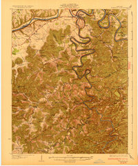
1932 Map of Burnside
USGS Topo · Published 1932About this map
Burnside serves as a critical junction on this 1928 survey, where the Cumberland River meets the South Fork and the Southern Railway corridor. The river's winding course is marked by dramatic topography and distinctive bends such as Woodson Bend, Martin Bend, and Roberts Bend, the latter featuring Roberts Mill. This area in southern Kentucky shows a dense network of early 20th-century rural life, with numerous community anchors like Lovells Chapel, Salem Ch, and Pole Bridge Sch dotting the landscape. The intricate terrain of the Cumberland Plateau is evident through features like The Gulf and a Natural Bridge near the Pulaski and McCreary County line. Further south, the map details many smaller settlements and schools, including Nevelsville, Coopersville, and Brammer Hill Sch, providing a clear look at the region's historical geography before later hydrological changes altered the river system.
Find a feature on this map
111 named features on this map. Tap any name to fly to it.
Don’t see what you’re looking for? This feature index may not catch every label — zoom into the map to look around manually.
Map Details
Editions of this 1932 Burnside Map
2 editions found
Other maps of this area

1890 · Williamsburg
USGS Topo · 1:125,000

1893 · London
USGS Topo · 1:125,000

1894 · Williamsburg
USGS Topo · 1:125,000

1897 · London
USGS Topo · 1:125,000

1911 · Monticello
USGS Topo · 1:62,500

1914 · Monticello
USGS Topo · 1:62,500

1934 · Barthell
USGS Topo · 1:62,500

1934 · Pall Mall
USGS Topo · 1:62,500

1935 · Somerset
USGS Topo · 1:62,500

1952 · Hail
USGS Topo · 1:24,000