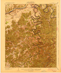
1932 Map of Burnside
USGS Topo · Published 1932About this map
The Cumberland River and its deep meanders define the landscape of this 1932 survey, notably at Burnside where the Southern Railway crosses the water. This era captures the region's river-dependent geography before modern reservoir systems altered the flow, showing tight loops like Woodson Bend and Dixie Bend as prominent landforms. The intricate topography is marked by numerous gap crossings such as Sullens Gap and Gaylor Gap, which facilitated travel between the steep hollows and ridges.
Find a feature on this map
91 named features on this map. Tap any name to fly to it.
Don’t see what you’re looking for? This feature index may not catch every label — zoom into the map to look around manually.
Map Details
Editions of this 1932 Burnside Map
2 editions found
Other maps of this area

1890 · Williamsburg
USGS Topo · 1:125,000

1893 · London
USGS Topo · 1:125,000

1894 · Williamsburg
USGS Topo · 1:125,000

1897 · London
USGS Topo · 1:125,000

1911 · Monticello
USGS Topo · 1:62,500

1914 · Monticello
USGS Topo · 1:62,500

1932 · Burnside
USGS Topo · 1:62,500

1934 · Barthell
USGS Topo · 1:62,500

1934 · Pall Mall
USGS Topo · 1:62,500

1935 · Somerset
USGS Topo · 1:62,500