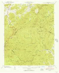
1942 Map of Dunsmore Mountain
USGS Topo · Published 1957About this map
Dunsmore Mountain and the high ridges of the Pisgah National Forest define this 1942 survey, where the border between Buncombe, Henderson, and Haywood counties meets. The landscape is a network of deep coves and gaps, including Berrys Gap and Glady Fork Gap, which served as critical passage points for local travel before modern highway development. Cultural landmarks like Pisgah Ch and the Kelly Cem sit near the northern edge, while the southern reaches feature The Pink Beds and the Buck Spring Lodge. This era reflects a transition toward managed conservation and recreation, evidenced by the Bent Creek Experimental Forest and the North Mills River Recreation Area. Numerous family-named features, such as Candler Knob and Young Pisgah Mtn, provide essential touchstones for genealogical research in this mountain region.
Find a feature on this map
135 named features on this map. Tap any name to fly to it.
Don’t see what you’re looking for? This feature index may not catch every label — zoom into the map to look around manually.
Map Details
Editions of this 1942 Dunsmore Mountain Map
2 editions found
Other maps of this area

1894 · Asheville
USGS Topo · 1:125,000

1901 · Asheville
USGS Topo · 1:125,000

1905 · Pisgah
USGS Topo · 1:125,000

1906 · Pisgah
USGS Topo · 1:125,000

1935 · Cruso
USGS Topo · 1:24,000

1935 · Canton
USGS Topo · 1:24,000

1935 · Horse Shoe
USGS Topo · 1:24,000

1935 · Shining Rock
USGS Topo · 1:24,000

1935 · Pisgah Forest
USGS Topo · 1:24,000

1936 · Enka
USGS Topo · 1:24,000