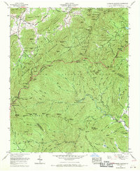
1967 Map of Dunsmore Mountain
USGS Topo · Published 1970About this map
Pisgah National Forest dominates this landscape where the boundaries of Buncombe, Henderson, and Transylvania counties converge. This 1960s survey illustrates a region largely dedicated to conservation and public management, divided into specialized zones like the Bent Creek Experimental Forest and several wildlife restoration areas. The winding route of the Blue Ridge Parkway traverses the high ridges, passing landmarks such as Buck Spring Gap and providing access to the sprawling high-altitude terrain.
Find a feature on this map
127 named features on this map. Tap any name to fly to it.
Don’t see what you’re looking for? This feature index may not catch every label — zoom into the map to look around manually.
Map Details
Editions of this 1967 Dunsmore Mountain Map
Other maps of this area

1894 · Asheville
USGS Topo · 1:125,000

1901 · Asheville
USGS Topo · 1:125,000

1905 · Pisgah
USGS Topo · 1:125,000

1906 · Pisgah
USGS Topo · 1:125,000

1935 · Cruso
USGS Topo · 1:24,000

1935 · Canton
USGS Topo · 1:24,000

1935 · Horse Shoe
USGS Topo · 1:24,000

1935 · Shining Rock
USGS Topo · 1:24,000

1935 · Pisgah Forest
USGS Topo · 1:24,000

1936 · Enka
USGS Topo · 1:24,000