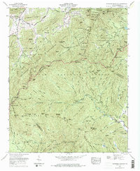
1967 Map of Dunsmore Mountain
USGS Topo · Published 1975About this map
Pisgah National Forest dominates this landscape, where the ridges of the Blue Ridge Mountains converge at the borders of Buncombe, Henderson, and Transylvania counties. The 1967 survey highlights a period of significant recreational and conservation management, marked by the extensive Pisgah Wildlife Management Area and the Bent Creek Experimental Forest. High-altitude infrastructure is a defining characteristic, particularly the winding path of the Blue Ridge Parkway which pierces the mountain ridges through several engineering feats including the Glady Fork Tunnel and the Pine Mountain Tunnel.
Find a feature on this map
100 named features on this map. Tap any name to fly to it.
Don’t see what you’re looking for? This feature index may not catch every label — zoom into the map to look around manually.
Map Details
Editions of this 1967 Dunsmore Mountain Map
Other maps of this area

1894 · Asheville
USGS Topo · 1:125,000

1901 · Asheville
USGS Topo · 1:125,000

1905 · Pisgah
USGS Topo · 1:125,000

1906 · Pisgah
USGS Topo · 1:125,000

1935 · Cruso
USGS Topo · 1:24,000

1935 · Canton
USGS Topo · 1:24,000

1935 · Horse Shoe
USGS Topo · 1:24,000

1935 · Shining Rock
USGS Topo · 1:24,000

1935 · Pisgah Forest
USGS Topo · 1:24,000

1936 · Enka
USGS Topo · 1:24,000