1981 Map of Duran
USGS Topo · Published 1981About this map
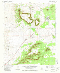
The high plains of eastern Torrance County are dominated by the massive plateau of Duran Mesa and the prominent Trinchera Mesa to the south. In the early 1980s, the small settlement of Duran served as a key point along the Southern Pacific railroad, which cuts diagonally across the landscape. The infrastructure of this arid region is clearly defined by a network of vital water sources, including the Railroad Well and Valencia Well, which sustained local ranching and transit operations.
Find a feature on this map
24 named features on this map. Tap any name to fly to it.
Don’t see what you’re looking for? This feature index may not catch every label — zoom into the map to look around manually.
Map Details
Editions of this 1981 Duran Map
This is the sole edition of this map. No revisions or reprints were ever made.
Other maps of this area

1954 · Fort Sumner
USGS Topo · 1:250,000

1958 · Fort Sumner
USGS Topo · 1:250,000

1978 · Tejon
USGS Topo · 1:24,000

1978 · Negra SE
USGS Topo · 1:24,000

1978 · Dunlap Ranch
USGS Topo · 1:24,000
1980 · Corona
USGS Topo · 1:100,000

1981 · Camaleon Draw West
USGS Topo · 1:24,000

1981 · Camaleon Draw East
USGS Topo · 1:24,000

1981 · Duran NE
USGS Topo · 1:24,000

1981 · Cedarvale NE
USGS Topo · 1:24,000