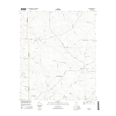
2014 Map of Durand
USGS Topo · Published 2014About this map
White Sulphur Springs and the village of Durand anchor this portion of the Georgia Piedmont, where the landscape is defined by the headwaters of Sulphur Cr and White Sulphur Cr. The terrain is marked by a high density of family and community burial grounds, such as Ogletree Cem, Glanton Cem, and Caldwell Williams Cem, reflecting a long history of local settlement and genealogical depth across the county line. The road network, including the Chipley Hwy, connects these rural outposts with larger centers like Stovall and Pine Mountain. Small impoundments like Vandegrift Lake and Williamson Lake suggest a managed rural environment where agricultural and residential life follow the contours of the land. This survey provides a clear view of the area's development before modern shifts, preserving the placement of churches like Spring Chapel Cem and named intersections like Hunters Crossroad.
Find a feature on this map
82 named features on this map. Tap any name to fly to it.
Don’t see what you’re looking for? This feature index may not catch every label — zoom into the map to look around manually.
Map Details
Editions of this 2014 Durand Map
This is the sole edition of this map. No revisions or reprints were ever made.
Other maps of this area

1907 · Talbotton
USGS Topo · 1:125,000

1934 · Warm Springs
USGS Topo · 1:62,500

1936 · Warm Springs
USGS Topo · 1:62,500

1953 · Atlanta
USGS Topo · 1:250,000

1955 · Phenix City
USGS Topo · 1:250,000

1957 · Phenix City
USGS Topo · 1:250,000

1957 · Atlanta
USGS Topo · 1:250,000

1958 · Phenix City
USGS Topo · 1:250,000

1958 · Atlanta
USGS Topo · 1:250,000
1964 · Mountville
USGS Topo · 1:24,000