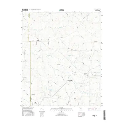
2017 Map of Durand
USGS Topo · Published 2017About this map
White Sulphur Springs and the surrounding high ground of Harris and Meriwether counties define this transition between the Piedmont and the Pine Mountain range. The landscape is a network of small family-named cemeteries and rural crossroads that persist even as the regional footprint of larger settlements like Durand and Stovall remains modest. The topography is shaped by the drainage of Sulphur Cr and White-Sulphur Cr, which cut through the terrain toward smaller impoundments such as Vandegrift Lake and Williamson Lake. This 2017 survey reflects a deeply traditional Georgia settlement pattern where local roads like Dallas Mill Rd and Harry Hardy Rd connect scattered homesteads and community landmarks. Genealogists will find a high density of burial sites, including the Grier Cem, Glanton Cem, and Coplan-Perry Cem, which serve as physical anchors for the area's rural history.
Find a feature on this map
77 named features on this map. Tap any name to fly to it.
Don’t see what you’re looking for? This feature index may not catch every label — zoom into the map to look around manually.
Map Details
Editions of this 2017 Durand Map
This is the sole edition of this map. No revisions or reprints were ever made.
Other maps of this area

1907 · Talbotton
USGS Topo · 1:125,000

1934 · Warm Springs
USGS Topo · 1:62,500

1936 · Warm Springs
USGS Topo · 1:62,500

1953 · Atlanta
USGS Topo · 1:250,000

1955 · Phenix City
USGS Topo · 1:250,000

1957 · Phenix City
USGS Topo · 1:250,000

1957 · Atlanta
USGS Topo · 1:250,000

1958 · Phenix City
USGS Topo · 1:250,000

1958 · Atlanta
USGS Topo · 1:250,000
1964 · Mountville
USGS Topo · 1:24,000