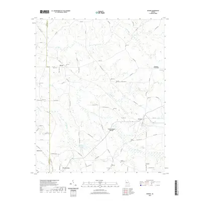
2020 Map of Durand
USGS Topo · Published 2020About this map
White Sulphur Springs and the surrounding rural landscapes of Harris County appear here during the transition into the 2020s. This survey records a high density of small family cemeteries and crossroads settlements that anchor the local geography. Significant clusters of burials, such as Tigner Cem, Grier Cem, and the Greer and Robertson Cem, are distributed along the ridges and winding roads like Stovall RD and Harry Hardy RD. The settlement patterns at Durand and Stovall reflect a long-standing rural community structure, where the proximity to numerous small watercourses like Flat Shoal Cr and White Sulphur Cr once dictated the placement of farms and homesites. To the south, the terrain descends toward Pine Mountain, showing the modern expansion of roads and residential development near McGees Pond and Mitcham Lake.
Find a feature on this map
78 named features on this map. Tap any name to fly to it.
Don’t see what you’re looking for? This feature index may not catch every label — zoom into the map to look around manually.
Map Details
Editions of this 2020 Durand Map
This is the sole edition of this map. No revisions or reprints were ever made.
Other maps of this area

1907 · Talbotton
USGS Topo · 1:125,000

1934 · Warm Springs
USGS Topo · 1:62,500

1936 · Warm Springs
USGS Topo · 1:62,500

1953 · Atlanta
USGS Topo · 1:250,000

1955 · Phenix City
USGS Topo · 1:250,000

1957 · Phenix City
USGS Topo · 1:250,000

1957 · Atlanta
USGS Topo · 1:250,000

1958 · Phenix City
USGS Topo · 1:250,000

1958 · Atlanta
USGS Topo · 1:250,000
1964 · Mountville
USGS Topo · 1:24,000