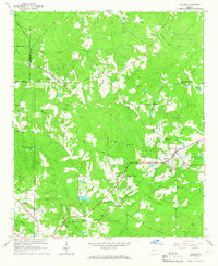
1964 Map of Durand
USGS Topo · Published 1966About this map
Durand and Stovall serve as central nodes in this western Georgia landscape, where the Atlantic Coast Line and Central of Georgia railroads intersect. The mid-century terrain is defined by a dense network of family-named cemeteries and rural congregations, including Wilson Chapel, Arbor Chapel, and Trinity Ch, signaling a well-established community structure. The presence of White Sulphur Springs and Meriwether White Sulphur highlights the area's local importance as a destination point near the winding courses of Sulphur Creek and Flat Shoal Creek.
Find a feature on this map
37 named features on this map. Tap any name to fly to it.
Don’t see what you’re looking for? This feature index may not catch every label — zoom into the map to look around manually.
Map Details
Editions of this 1964 Durand Map
This is the sole edition of this map. No revisions or reprints were ever made.
Other maps of this area

1907 · Talbotton
USGS Topo · 1:125,000

1934 · Warm Springs
USGS Topo · 1:62,500

1936 · Warm Springs
USGS Topo · 1:62,500

1953 · Atlanta
USGS Topo · 1:250,000

1955 · Phenix City
USGS Topo · 1:250,000

1957 · Phenix City
USGS Topo · 1:250,000

1957 · Atlanta
USGS Topo · 1:250,000

1958 · Phenix City
USGS Topo · 1:250,000

1958 · Atlanta
USGS Topo · 1:250,000
1964 · Mountville
USGS Topo · 1:24,000