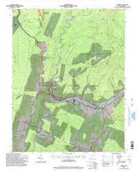
1995 Map of Durbin
USGS Topo · Published 1998About this map
The Greenbrier River serves as the central artery for this mountainous region of West Virginia, where the East Fork and West Fork converge near the town of Durbin. The industrial footprint of the mid-1990s is visible through the sawmill and industrial waste ponds at Frank, alongside a coal washing plant and strip mine further north at Cheat Bridge. This era of development is juxtaposed with the protected landscapes of the Gaudineer Scenic Area and Monongahela National Forest. Historical settlement patterns are preserved in the form of family-named cemeteries such as Yeager Cem and Hauchen Cem, and the community of Burner Settlement situated along Grassy Ridge. Recreational and rural infrastructure includes a drive-in theater near Bartow and a swinging bridge crossing the river at Nottingham.
Find a feature on this map
49 named features on this map. Tap any name to fly to it.
Don’t see what you’re looking for? This feature index may not catch every label — zoom into the map to look around manually.
Map Details
Editions of this 1995 Durbin Map
This is the sole edition of this map. No revisions or reprints were ever made.
Other maps of this area

1889 · Beverly
USGS Topo · 1:125,000

1892 · Beverly
USGS Topo · 1:125,000

1901 · Monterey
USGS Topo · 1:125,000

1922 · Spruce Knob
USGS Topo · 1:48,000

1922 · Cass
USGS Topo · 1:48,000

1922 · Durbin
USGS Topo · 1:48,000

1924 · Cass
USGS Topo · 1:62,500

1924 · Durbin
USGS Topo · 1:62,500

1924 · Spruce Knob
USGS Topo · 1:62,500

1941 · Monterey
USGS Topo · 1:62,500