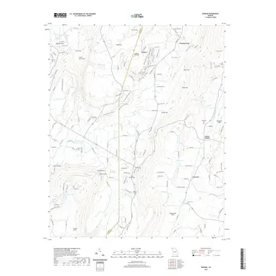
2020 Map of Durham
USGS Topo · Published 2020About this map
Lookout Mountain dominates this portion of the Georgia landscape, where the plateau terrain is etched by deep gaps and gulches along the border of Dade and Walker Counties. The community of Durham sits atop the mountain, surrounded by a network of specialized paths like the Slickenside Trail, Kettle Bottom Trail, and Hanging Wall, reflecting the area's geological and industrial character. To the east, the terrain drops into the valley where the settlements of Cassandra, Thompsonville, and Cooper Heights align along the base of Missionary Ridge. This 2020 survey documents a transition from the high, rugged crests at Newsome Gap and Steven Gap to the water-rich lowlands of Chattanooga Valley. Genealogists will find several family-named burial sites documented across the varied topography, including Coulter Cem, Stephens Cem, and the Old Lookout Cem located near the northern reaches of Mill Cr.
Find a feature on this map
159 named features on this map. Tap any name to fly to it.
Don’t see what you’re looking for? This feature index may not catch every label — zoom into the map to look around manually.
Map Details
Editions of this 2020 Durham Map
This is the sole edition of this map. No revisions or reprints were ever made.
Other maps of this area

1886 · Ringgold
USGS Topo · 1:125,000

1886 · Stevenson
USGS Topo · 1:125,000

1892 · Ringgold
USGS Topo · 1:125,000

1892 · Stevenson
USGS Topo · 1:125,000

1895 · Stevenson
USGS Topo · 1:125,000

1935 · Durham
USGS Topo · 1:24,000

1936 · Trenton
USGS Topo · 1:24,000

1936 · Shellmound
USGS Topo · 1:24,000

1936 · Kensington
USGS Topo · 1:24,000

1936 · Hooker
USGS Topo · 1:24,000