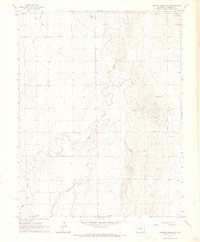
1966 Map of Durkee Creek NW
USGS Topo · Published 1967About this map
Two Butte Creek winds through the eastern plains of Prowers County, defining a landscape where water management and shifting terrain meet. This mid-1960s survey documents a sparse agricultural and rangeland environment, characterized by the Lamar Canal in the northwest and a network of seasonal drainages including Plum Creek and Durkee Creek. A notable topographical feature is the extensive area of Shifting Sand along the eastern margin, indicating the active dune formations typical of this high plains region. The map provides a precise record of rural infrastructure, from a lonely Radio Tower to numerous fence and field lines that mark out the sectioned land of the high prairie. The sparse settlement pattern emphasizes the dominance of the natural landscape and the critical role of irrigation and creek systems in the local economy.
Find a feature on this map
10 named features on this map. Tap any name to fly to it.
Don’t see what you’re looking for? This feature index may not catch every label — zoom into the map to look around manually.
Map Details
Editions of this 1966 Durkee Creek NW Map
This is the sole edition of this map. No revisions or reprints were ever made.
Other maps of this area

1890 · Granada
USGS Topo · 1:125,000

1891 · Albany
USGS Topo · 1:125,000

1892 · Granada
USGS Topo · 1:125,000

1893 · Albany
USGS Topo · 1:125,000

1894 · Granada
USGS Topo · 1:125,000

1953 · Holly West
USGS Topo · 1:24,000

1953 · Granada
USGS Topo · 1:24,000

1953 · Holly East
USGS Topo · 1:24,000

1954 · Lamar
USGS Topo · 1:250,000

1955 · La Junta
USGS Topo · 1:250,000