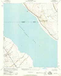
1957 Map of Durmid
USGS Topo · Published 1957About this map
The Salton Sea dominates this mid-century landscape, capturing a moment when the shoreline was recorded at 241 feet below sea level. Along the northeastern shore, the Southern Pacific railroad corridor serves as the primary artery, linking small siding settlements like Durmid and Bertram against the backdrop of the Bat Caves Buttes. On the opposite southwestern shore, the desert terrain is defined by complex drainage patterns including Grave Wash, Coral Wash, and Salada Wash, which descend toward the water from higher ground.
Find a feature on this map
22 named features on this map. Tap any name to fly to it.
Don’t see what you’re looking for? This feature index may not catch every label — zoom into the map to look around manually.
Map Details
Editions of this 1957 Durmid Map
This is the sole edition of this map. No revisions or reprints were ever made.
Other maps of this area

1904 · Indio
USGS Topo · 1:125,000

1931 · Vallecito
USGS Topo · 1:125,000

1940 · Kane Spring
USGS Topo · 1:62,500

1940 · Frink
USGS Topo · 1:62,500

1940 · Cottonwood Spring
USGS Topo · 1:62,500

1940 · Canyon Spring
USGS Topo · 1:62,500

1940 · Durmid
USGS Topo · 1:62,500

1941 · Coachella
USGS Topo · 1:62,500

1942 · Barrel Spring
USGS Topo · 1:62,500

1942 · Agua Dulce
USGS Topo · 1:62,500