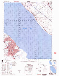
2002 Map of Durmid
USGS Topo · Published 2004About this map
Salton City anchors the southwestern shore of the Salton Sea in this early 21st-century map, revealing the intricate street grids and residential planning characteristic of this desert community. The landscape is defined by the intersection of nature and infrastructure, where the Southern Pacific Railroad skirts the northeastern shoreline through rail sidings at Durmid and Bertram. This area reflects a complex geography of resource management and conservation, bordered by the Torres Martinez Indian Reservation and the Salton Sea National Wildlife Refuge. The eastern edge is dominated by the restricted terrain of the Chocolate Mountain Aerial Gunnery Range, while natural features like Bat Caves Buttes and drainage systems such as Tule Wash and Arroyo Salada mark the arid basin floor. Industrial and military presence is noted through the Salton Sea Test Base B-1 and various sewage disposal sites serving the local population centers.
Find a feature on this map
19 named features on this map. Tap any name to fly to it.
Don’t see what you’re looking for? This feature index may not catch every label — zoom into the map to look around manually.
Map Details
Editions of this 2002 Durmid Map
This is the sole edition of this map. No revisions or reprints were ever made.
Other maps of this area

1904 · Indio
USGS Topo · 1:125,000

1931 · Vallecito
USGS Topo · 1:125,000

1940 · Kane Spring
USGS Topo · 1:62,500

1940 · Frink
USGS Topo · 1:62,500

1940 · Cottonwood Spring
USGS Topo · 1:62,500

1940 · Canyon Spring
USGS Topo · 1:62,500

1940 · Durmid
USGS Topo · 1:62,500

1941 · Coachella
USGS Topo · 1:62,500

1942 · Barrel Spring
USGS Topo · 1:62,500

1942 · Agua Dulce
USGS Topo · 1:62,500