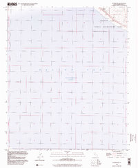
1998 Map of Durmid SE
USGS Topo · Published 2003About this map
Salton Sea dominates this corner of the Imperial Valley, where the shoreline was recorded at an elevation of 228 feet below sea level during the early 1990s. The map illustrates a landscape of extreme topography and conservation, featuring the Salton Sea National Wildlife Refuge and a large State Recreation Area along the northeastern coast. The settlement of Bertram stands as a lonely landmark near the water’s edge, positioned where the desert meets the inland sea. This edition reflects a period of stabilization in the basin's mapping, utilizing topography compiled in the 1950s but updated with planimetric data from 1992 and photoinspected in the late 1990s to ensure the accuracy of the shoreline and desert boundaries.
Find a feature on this map
9 named features on this map. Tap any name to fly to it.
Don’t see what you’re looking for? This feature index may not catch every label — zoom into the map to look around manually.
Map Details
Editions of this 1998 Durmid SE Map
This is the sole edition of this map. No revisions or reprints were ever made.
Other maps of this area

1940 · Kane Spring
USGS Topo · 1:62,500

1940 · Frink
USGS Topo · 1:62,500

1940 · Durmid
USGS Topo · 1:62,500

1944 · Durmid
USGS Topo · 1:62,500

1944 · Kane Spring
USGS Topo · 1:62,500

1944 · Calipatria
USGS Topo · 1:62,500

1944 · Frink
USGS Topo · 1:62,500

1954 · Salton Sea
USGS Topo · 1:250,000

1955 · Salton Sea
USGS Topo · 1:250,000

1956 · Frink NW
USGS Topo · 1:24,000